I wrote a short article about this resource a few years ago, so I thought I would give you all a chance to have a look.
A jointly funded project, Bomb Sight, has been created to map the London WW2 bomb census between 7 October 1940 and 6 June 1941, which had previously only been available at the National Archives.
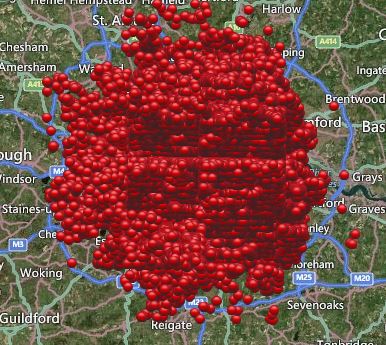
Bomb Site map of London within M25
Visitors to the sight can explore the map by dragging, section by section which can be quite hard to find your way around due to the very large number of red circles – just shows how Londoners suffered, or enter a street or area. By clicking on one of the circles you can see what type of bomb hit the area. The read more section can sometimes give a lot more details i.e. current address, people’s memories and sometimes photographs
Take for example one of Londons tourist attractions, Buckingham Palace, within the period covered by the census over 25 bombs fell within the boundary of the palace or very close. The Tower of London and Tower Bridge also feared no better with over 15 bombs landing close.
Taking a look at the map, so that you can see all of the London are, it seems there was no peace for anyone inside the M25, even up to St Albans, Hatfield and Hoddesdon.
A drop down menu gives you the options of, the first day of the Blitz, street view, anti-invasion sights, 1940’s bomb map. Another menu gives you the option of seeing the first night, weekly or aggregate bomb census.
Why not grab yourself a cuppa, take five minutes and explore. It does not matter if you have family from the London area or not – I guarantee you will spend more time there than you planned.